
Chinese name: drone intelligent transportation
Foreign Name: UAV Intelligent Transportation
table of Contents
Background overview
Drone related concept
Limitations of fixed surveillance video probes
Drones participate in traffic supervision
• UAVs for traffic flow control
• Image Processing
• Flight Control System
• UAV ground station function integration
• Drone communication command vehicle
Background overview
The rapid development of global cities has led to an increase in urban vehicles, an increasingly complex transportation network, and rapid development of intercity trains and high-speed rail vehicles. While the urban transportation network brings convenience to people's lives, the complicated situation of vehicles has also buried hidden dangers for traffic safety, leaving more problems for traffic control and management.
At present, the existing traffic monitoring mainly relies on traffic police patrols, fixed-point camera monitoring, etc. The angle of view presented is relatively narrow and the image is not clear enough. When traffic jams occur around the accident site, it is difficult to obtain the image data of the first-hand scene. There are also numerous monitoring vulnerabilities and dead ends. For example, if a manned helicopter is dispatched to patrol, it will cost a high fee for each engine oil consumption. The costly cost greatly reduces the possibility of daily real-time surveys; and the huge fuselage can't go deep into the narrow streets for shooting or investigation, and its implementation is almost zero.
UAVs participating in urban traffic management can give full play to their own expertise and advantages, and help public security city traffic management departments to jointly solve the traffic ills in large and medium-sized cities. It can not only ensure the implementation of urban transportation development plans from a macro perspective, but also conduct live monitoring from the micro level. The regulation of traffic flow, the construction of water, land and air three-dimensional traffic control, to achieve regional control, to ensure smooth traffic, to respond to sudden traffic incidents, to implement emergency rescue.
Drone related concept
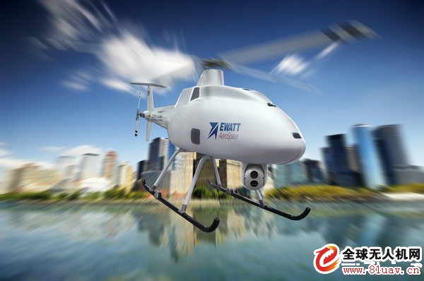
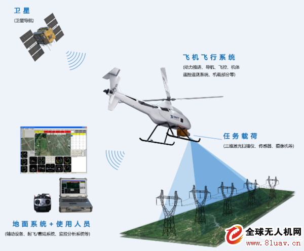
The drone is the abbreviation of "unmanned aerial vehicle" or "remotely piloted aircraft". It can be used for military reconnaissance and surveillance, target location, bait, fire attack, battle damage assessment, and electronic countermeasures and communication relay. The drone can be integrated with high-definition camera equipment. The system mainly includes: carrier, flight control, gyro head, video transmission, ground station and call system. The multi-rotor UAV is currently flying within 500 meters, suitable for Shoot high-definition images in a variety of complex conditions.
Limitations of fixed surveillance video probes
1. Limited coverage;
2. Expensive;
3. Only very small areas (city highways) cover advanced traffic monitoring systems like CCTV and VID;
4. Secondary roads in rural areas and urban areas are not covered;
5. The use of helicopters for highway monitoring has high requirements for pilots and the inability to process real-time data.
Drones participate in traffic supervision
With the rapid increase in the number of motor vehicles and the continuous extension of the urban road network, although the traffic police department has continuously increased investment in traffic technology monitoring equipment, the new fixed-type traffic technology monitoring equipment still cannot fully meet the needs of traffic supervision. Gradually improve the electronic monitoring network to provide a good guarantee for road traffic management and public security, and drones can play an important role in intelligent traffic supervision.
UAV for traffic flow control
1. Automatically collect road condition information using a high-definition camera or camera mounted on the drone;
2. Transfer the captured video signal or picture signal by using the image transmission system carried by the drone;
3. Use the flight control system of the drone to implement autonomous flight to achieve intelligent monitoring.
Image Processing
1. High-stability, high-sensitivity image transmission circuit design, stable image, superior image quality, and more advantages in the use of densely populated areas;
2. 3-axis suspension flight head, which can be equipped with visible light, infrared, and other airborne equipment. The pan/tilt has grid axis stability and automatic correction function;
3. Equipped with a high-infrared camera or HD camera, the images are perfectly sharp.
Flight control system
The UAV combines GPS, 6-DOF inertial measurement unit, magnetic field meter, barometric altimeter and other sensor units to optimize the theoretical model of robotic control such as high robustness H infinity algorithm and expert system, providing high stability and reliability. The flight control core module makes the UAV system a fully automatic aerial work platform. Multiple flight control modes provide the possibility to work in different environments. The attitude mode maintains accurate height locking and smooth attitude balance.
Strengthening out-of-control protection, the drone machine can automatically hover when it loses the remote control signal. After more than 10 seconds, the flight control system calculates the best route for returning and directs the drone to return to ensure the safe return of the drone.
Accurate hovering, even in windy weather, the accuracy of the hover will not be affected.
UAV ground station function integration
Integrated GPS geographic information system to control the drone's target waypoint flight and improve the accuracy of the drone flight path.
Modify the route settings in time during flight, alert the ground station if the positioning is not good, and hover at a fixed point during the flight.
Record telemetry data to display the flight status of the drone (flight mileage, time, altitude, voltage, GPS status, etc.).
Drone communication command vehicle
UAV's self-developed UAV communication command vehicle can realize long-distance monitoring of UAVs by using various in-vehicle equipments, and install high-power video receivers, telescopic antennas, fixed-wing UAV catapults , and high precision. Devices such as RTK can perform efficient and mobile control of drones.
Application range
1. Railway transportation:
The railway construction has a long mileage and there are many sensitive information along the route. At present, the railway adopts the manual stepping method, which has a huge workload. At the same time, due to natural disasters, terrain, weather and other conditions, it is difficult to carry out investigations in special sections, resulting in incomplete and inaccurate engineering acceptance.
In the course of railway line selection, railway address survey and ecological evaluation, the UAV has real-time remote video transmission function of 3G network, which can transmit the video image of the drone to the mobile terminal or command center anywhere in the world in real time, providing railway construction. A large number of data sources greatly improve work efficiency. The drone's body is light and reliable, compact in structure and excellent in performance. It is not restricted by geographical conditions and environmental conditions. It can be used in railways with multiple locations, scattered locations and complex on-site environment.
After the coordinates are input at the ground station, the drone enters the scheduled flight orbit through the ground control station, and the images of the railway and its lines can be clearly transmitted back, the hazards are discovered in time, the safety of the communication equipment and the information are smoothed, and the daily life is reduced. The workload of personnel inspections, increase labor productivity, and better serve the railway safe transportation production.
2. Road transport:
In the road transport, the use of the drone system is an important scientific and technological means of monitoring in the construction of intelligent traffic. The UAV system can realize real-time monitoring of the road surface, timely discover road traffic accidents, dynamically investigate and deal with various traffic violations such as road surface violations, improve traffic police monitoring and management efficiency, and ensure smooth roads.
Compared with the traditional aerial photography mode, UAV mapping can not only enhance the accuracy of data, but also improve efficiency. The UAV system provides a new way of monitoring road traffic. It is equipped with high-definition cameras and full-scale shooting of the road. It not only satisfies the needs of relevant departments for highway aerial photography, but also provides survey and design work for highway construction. , providing strong technical support.
2.1 Site survey of mega traffic accidents
Traditional exploration methods are time-consuming and labor-intensive, and the dangers may cause secondary accidents. The accidental data collection is too slow to miss the best rescue time, while the drone body is light and reliable, compact and excellent in performance. Restricted by geographical conditions and environmental conditions, you can go deep into all kinds of complex areas, quickly reach the scene of the incident, conduct rapid and comprehensive investigations on the terrain, vehicle damage, casualties, and improve the scientific and efficient exploration and rescue work. Sex.
2.2 Maintaining traffic order
The drone has real-time remote video transmission function of 3G network, and the image transmission speed is fast, and the real-time image can be transmitted back to the traffic command center, so that the traffic command center can obtain the deployment status of the patrol vehicle and the police officer at the first time, so that the real-time image can be released in time. Command orders, manage traffic order, and avoid traffic congestion in important periods and major occasions. Once the alarm is discovered, the command center can quickly locate and deploy the nearest patrol police force to achieve the fastest processing and effectively improve traffic management efficiency.
The drone flies to the congested site, and conducts a rapid and accurate survey of congestion causes, congestion lengths, and congested vehicles. The traffic command center quickly and reasonably and accurately intercepts the congested road sections based on the image data returned by the drone in real time. .
3. Waterway transportation:
Waterway transportation is the earliest and longest-lasting mode of transportation among the major modes of transportation. With the rapid development of China's economy, the throughput of domestic ports is also increasing. The trend of large-scale shipbuilding and specialization is obvious, and the risk of water pollution is also coming.
At present, water transportation mainly adopts traditional means such as ship cruise, regular cruise of air fixed-wing aircraft, and satellite remote sensing monitoring. Compared with traditional methods such as ship cruise, regular fixed-air cruise, and satellite remote sensing, the drone has the advantages of low cost, low cost and strong real-time performance.
The drone has the function of rainproof: it can fly in heavy rain and medium snow, and the waterproof level reaches IPX4 during flight, which is not affected by the changing weather at sea.
The drone has a high-precision airborne GPS device that can set the route to fly automatically. The use of drones for fixed-point monitoring will also have a deterrent effect on ships operating in violation of regulations.
4. Air transportation
The rapid development of the air transport industry has placed higher demands on the safety management of airports. Airport security has attracted the attention of governments and the great attention of the international community. The airport, especially the large and medium-sized aviation hub airport, is like an independent “city poolâ€. It has a large area, a large flight area, a large terminal building, large passenger and cargo flow, and large aircraft movements. If it is only manually conducted for safety monitoring and management. It is very difficult to work. It is necessary to use advanced technical means to prevent early detection and early suppression, and to eliminate insecure factors in the bud.
The drop-off area is the key monitoring area of ​​the airport. There are many pedestrians and motor vehicles in the area, which are prone to traffic disputes and traffic accidents. UAV cruise monitoring can be used to detect areas that cannot be monitored by ordinary video surveillance. Real-time remote video transmission through the 3G network of the drone can realize real-time monitoring, effectively prevent drivers from operating illegally, and greatly improve the order of passengers waiting in line. Find passengers lost luggage, etc.
Due to the large flight area of ​​the airport, it is difficult to find an accident after the landing of the aircraft. The maximum flight altitude of the drone is 2,000 meters, the flight radius is 5 kilometers, the one-way mission distance is 10 kilometers, and the flight speed is 80 kilometers/hour. It is especially suitable for large-area search and rescue. The scope of the cruise search and rescue work.
Advantage
The next UAV can take a bird's eye view of the ground traffic flow, which is conducive to the overall situation of the traffic control department, overall command and correct channeling. Compared with manned general-purpose aircraft and manned helicopters, drones can fly lower, closer to the vehicles and personnel, and they are more clearly observed.
Compared with the task of dispatching multiple police cars, the drone can fly at low altitude, with short path, fast speed, flexible viewing angle and large range of activities, which is conducive to the traffic management department to control the situation quickly and efficiently.
Long-term blanks are compared with manned general-purpose aircraft and manned helicopters. The drones have a long period of time and can carry out long-term urban traffic patrols. This is a long-term search for drones when the target area is locked. The task is very suitable.
High efficiency One-to-one drones have short ground handling and short-term preparation time, and can be dispatched at any time. Compared with manned general-purpose aircraft, manned helicopters, or other means of transportation, they have low input and high efficiency.
Low risk - In the process of participating in urban traffic management, drones can perform high-risk tasks in disaster weather or polluted environments. Practice has shown that UAVs have an unparalleled advantage over manned general aircraft, manned helicopters, or other means of transportation in the detection of dust storms, chemical pollution, and radioactive contamination.
Aeronautical Networking - Compared to other traditional aircraft, the aeronautical network allows drones to be used online. After selecting the application software and system, the drone can play the function of “one frame to multiple shelvesâ€; the aeronautical network makes the UAV system highly integrated, intelligent, and comprehensive; the aeronautical network is standardized for drones. The generalized and serialized design leaves room for upgrading, improving quality and adding functions according to needs. The aeronautical network makes the UAV multi-purpose platform safe and practical, and the aeronautical network makes the drone reach “green low carbonâ€. An environmentally friendly standard and leading the advancement of aviation technology.
It is possible to save the manpower and reduce the service cost by replacing the more ground police forces with fewer racks in the urban traffic management.
Maneuverable and flexible - in participating in urban traffic management, drones can fly on highways and bridges, and can travel between high-rise buildings, and even through tunnels for accident site exploration and forensics. Flexibility and mobility.
Emergency rescue: In the event of natural disasters such as earthquakes, floods, tsunamis, blizzards, etc., the ground traffic is completely paralyzed. Some people are flying and helicopters are in danger. The drones can be dispatched immediately, and the scenes are observed on the spot, and they are put into aerial photography. Establish communication relays and airdrop first aid drugs to rescue the wounded.
Public Security Prevention - When the UAV participates in urban traffic management, it can not only catch up with the embarrassing escape vehicles, but also warn the escapers in advance, and then respond to the opportunity, using tear gas, projection traps and other means.
Remote Vibration Collar,Rechargeable Dog Training Collar,Remote Dog Training Collars,Long Range Dog Training Collar
Elite-tek Electronics Ltd , https://www.aetertek.ca