1. Accurate flight data requirements
Beijing Tianlifa Group (micro-signal: bjtianlifa) believes that drone technology can greatly improve the efficiency of GIS professional technicians, and can obtain high-quality aerial imagery for a small and medium-sized work area without any drone control skills. And can convert them into the required 2D and 3D results.
As a new method for collecting raster data, UAV technology is a favorable complement to satellite/manned aircraft data acquisition technology. Although the coverage is low and time-consuming, high-resolution data can be obtained.
♦ From the point of view of the delivery time, the drone is now strong and can fly as much as you like – collecting geographic images requires no waiting for people to fly a plane or satellite image, as well as images of various factors such as weather, time. Differences, cost issues. Make a flight plan, collect image data, process data, and complete it in one day from start to finish.
♦ In terms of resolution and system, such as the DT DOM/ 3 d model, the accuracy is about 1-3X GSD, or 1.1 centimeters per pixel, which is significantly higher than the resolution that current satellites and manned aircraft can achieve.
♦ In addition, due to the flying height of the drone, there is no cloud cover, and the weather image is smaller, which means less weather delays and smaller unusable photos.
Beijing Tianlifa Group (micro-signal: bjtianlifa) believes that no matter which field you are in—forestry, asset management, environmental protection, agriculture, remote sensing, oil and gas, drones can provide you with substantial benefits and provide accurate Data, fast and low cost.
2, GIS drone workflow
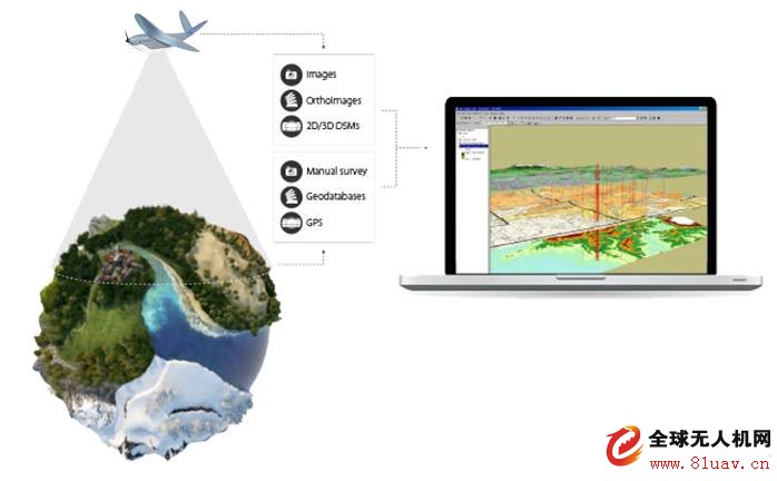
UAV data acquisition & generation of raster data · Flight plan · Takeoff (image data acquisition)
· Image Download & Processing · Generate DOM/DSM
Vector Data Extraction · GPS Recording · Geographical Coordinate Data · Feature Point Extraction · Digitization · Network Service · Point Cloud
Import & Quantitative Layering & Raster Data · GIS Software
Analysis & Decision Making · Progress Tracking, Feature Identification, Flood Simulation, Project Planning, etc.
3. Case Study & Report
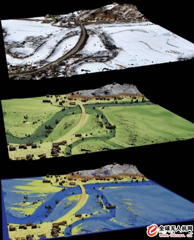
2015-3-20 Transportation Department Flood Monitoring Project. Outcome data: Point cloud, 3D terrain model, using terrain model and software under simulated flood conditions to create fast terrain simulations.
How to buy and consult delair-tech industrial grade drones?
Please call 24 hours customer service
Beijing Tianlifa Group (micro-signal: bjtianlifa) believes that drone technology can greatly improve the efficiency of GIS professional technicians, and can obtain high-quality aerial imagery for a small and medium-sized work area without any drone control skills. And can convert them into the required 2D and 3D results.
As a new method for collecting raster data, UAV technology is a favorable complement to satellite/manned aircraft data acquisition technology. Although the coverage is low and time-consuming, high-resolution data can be obtained.
♦ From the point of view of the delivery time, the drone is now strong and can fly as much as you like – collecting geographic images requires no waiting for people to fly a plane or satellite image, as well as images of various factors such as weather, time. Differences, cost issues. Make a flight plan, collect image data, process data, and complete it in one day from start to finish.
♦ In terms of resolution and system, such as the DT DOM/ 3 d model, the accuracy is about 1-3X GSD, or 1.1 centimeters per pixel, which is significantly higher than the resolution that current satellites and manned aircraft can achieve.
♦ In addition, due to the flying height of the drone, there is no cloud cover, and the weather image is smaller, which means less weather delays and smaller unusable photos.
Beijing Tianlifa Group (micro-signal: bjtianlifa) believes that no matter which field you are in—forestry, asset management, environmental protection, agriculture, remote sensing, oil and gas, drones can provide you with substantial benefits and provide accurate Data, fast and low cost.
2, GIS drone workflow
UAV data acquisition & generation of raster data · Flight plan · Takeoff (image data acquisition)
· Image Download & Processing · Generate DOM/DSM
Vector Data Extraction · GPS Recording · Geographical Coordinate Data · Feature Point Extraction · Digitization · Network Service · Point Cloud
Import & Quantitative Layering & Raster Data · GIS Software
Analysis & Decision Making · Progress Tracking, Feature Identification, Flood Simulation, Project Planning, etc.
3. Case Study & Report
2015-3-20 Transportation Department Flood Monitoring Project. Outcome data: Point cloud, 3D terrain model, using terrain model and software under simulated flood conditions to create fast terrain simulations.
How to buy and consult delair-tech industrial grade drones?
Please call 24 hours customer service
Fashion backpack men's and women's boutique backpack waterproof and breathable Backpack
Dongguan City Diadia Industry Co.,Ltd , https://www.diadiabag.com